Friday, July 30, 2021

Creating Sustainable Change in Downtown San Francisco

Creating Sustainable Change in Downtown San Francisco
By Shayda Haghgoo

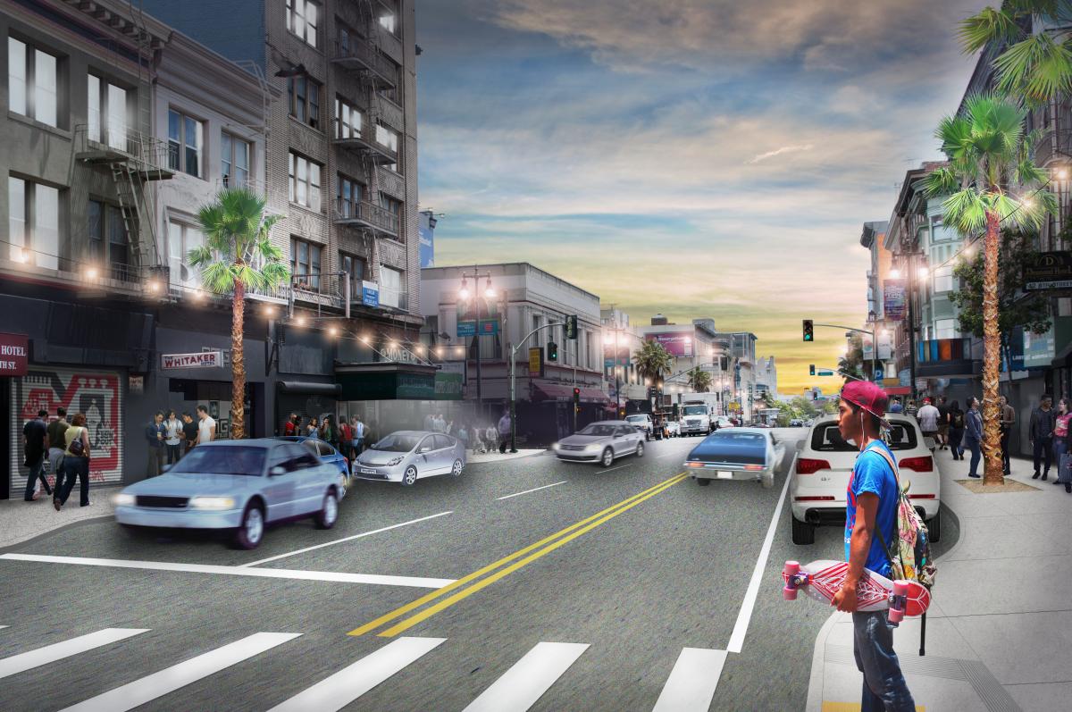
Rendering showing completed improvements on 6th Street between Market and Howard Streets

Rendering of 6th Street between Market and Howard Streets

When planning for new projects in Downtown San Francisco, the SFMTA must look at potential sites through multiple lenses:  

  • How did previous planning decisions that funnel traffic through the Tenderloin to freeway onramps in SoMa influence existing street conditions?  

  • How can we leverage quick-builds and capital streetscape projects now to make the streets safer not only today, but far into the future as well? 

This dual-pronged approach allowed the SFMTA to address immediate safety issues along 6th and Taylor streets while collaborating with San Francisco Public Works to bring capital improvements to these corridors. 

6th and Taylor streets are among the 13%  of city streets that account for 75% of severe traffic injuries and fatalities known as the Vision Zero high-injury network. The communities that live along these corridors largely consist of seniors, children, people with disabilities, limited English proficient people, and lower-income families—all of whom face higher risks of traffic collisions resulting in injury and/or death.  

Both the 6th Street Pedestrian Safety and Safer Taylor Street projects were legislated in the fall of 2018. Within a year, the SFMTA constructed its first quick-build improvements along 6th and Taylor streets to address critical pedestrian safety needs. These included: 

  • Travel lane reconfigurations to calm traffic and limit last minute lane changes 

  • Signal changes and left-turn restrictions to manage traffic flow and reduce collisions 

  • Curb management and buffered parking lanes to prioritize passenger and commercial loading zones 

  • Painted safety zones and daylighting to slow fast turning vehicles and improve visibility of people walking  

These changes reduced opportunities for conflict between motorists and sidewalk users while accommodating the community’s various street usages. After implementation, evaluation showed a 21% decrease in vehicle speeds on average along 6th Street, and a 100% reduction in double parking along Taylor Street. Larger capital projects take time to design and bid, but the SFMTA did not have to compromise on street safety. The quick-build improvements were installed while the projects’ construction-heavy streetscape elements were still being refined. 
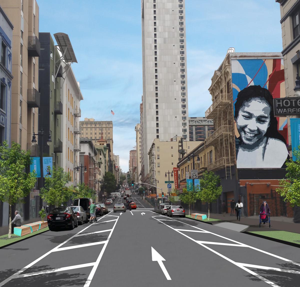
Photo rendering showing completed improvements on Taylor Street between Turk and Ellis StreetsRendering of Taylor Street between Turk and Ellis Streets 

While quick-builds address many of the immediate traffic safety needs, capital streetscape improvements like signal upgrades and landscape amenities will improve the quality of life by allowing protected and dedicated crossing times for people walking and creating inviting spaces. Many downtown residents live in small quarters like single-resident occupancy (SRO) properties, often with little to no outdoor space. The sidewalks along these corridors often function as an extension of people’s homes. Widening the sidewalks will enhance the space and allow a clear path of travel, especially for those using mobility devices, like wheelchairs.  

Capital improvements also allow for more possibilities to incorporate community elements and identity. 6th Street is part of the Filipino Cultural District, and both 6th and Taylor streets are part of the Transgender District, the first legally recognized transgender district in the world. Throughout the detailed design phase, we have been working closely with local groups such as SOMA Pilipinas and The Transgender District to implement community-identifying decorative crosswalks. These improvements will build off the previous quick-build work to further enhance safety and livability for people walking along these corridors.  

Since fall 2018, the SFMTA and Public Works teams have been diligently designing construction plans that include sidewalk widening with corner bulb-outs to shorten crossing distances and reduce speeds of turning vehicles, new and upgraded utilities and traffic signals and streetscape amenities such as new trees, benches, and decorative crosswalks. 

These project elements will continue to enhance the walking, biking, shopping, and living experiences of the 6th and Taylor Street communities. Due to unique issues below street level involving utilities and sub-sidewalk basements along the project corridors, these projects will require extensive construction.  

While the SFMTA led the planning and legislation processes of these projects, we will be handing the baton to San Francisco Public Works to manage implementation and construction communication. As construction begins, both agencies will continue to reach out to the community to minimize disruption to merchants, residents, and visitors along 6th and Taylor streets. For more information, please visit SFMTA.com/6thSt and SFMTA.com/Taylor


Published July 31, 2021 at 06:23AM
https://ift.tt/3rNZt6L
Creating Sustainable Change in Downtown San Francisco

Creating Sustainable Change in Downtown San Francisco
By Samantha Serafica

Rendering showing completed improvements on 6th Street between Market and Howard Streets

Rendering of 6th Street between Market and Howard Streets

When planning for new projects in Downtown San Francisco, the SFMTA must look at potential sites through multiple lenses:  

  • How did previous planning decisions that funnel traffic through the Tenderloin to freeway onramps in SoMa influence existing street conditions?  

  • How can we leverage quick-builds and capital streetscape projects now to make the streets safer not only today, but far into the future as well? 

This dual-pronged approach allowed the SFMTA to address immediate safety issues along 6th and Taylor streets while collaborating with San Francisco Public Works to bring capital improvements to these corridors. 

6th and Taylor streets are among the 13%  of city streets that account for 75% of severe traffic injuries and fatalities known as the Vision Zero high-injury network. The communities that live along these corridors largely consist of seniors, children, people with disabilities, limited English proficient people, and lower-income families—all of whom face higher risks of traffic collisions resulting in injury and/or death.  

Both the 6th Street Pedestrian Safety and Safer Taylor Street projects were legislated in the fall of 2018. Within a year, the SFMTA constructed its first quick-build improvements along 6th and Taylor streets to address critical pedestrian safety needs. These included: 

  • Travel lane reconfigurations to calm traffic and limit last minute lane changes 

  • Signal changes and left-turn restrictions to manage traffic flow and reduce collisions 

  • Curb management and buffered parking lanes to prioritize passenger and commercial loading zones 

  • Painted safety zones and daylighting to slow fast turning vehicles and improve visibility of people walking  

These changes reduced opportunities for conflict between motorists and sidewalk users while accommodating the community’s various street usages. After implementation, evaluation showed a 21% decrease in vehicle speeds on average along 6th Street, and a 100% reduction in double parking along Taylor Street. Larger capital projects take time to design and bid, but the SFMTA did not have to compromise on street safety. The quick-build improvements were installed while the projects’ construction-heavy streetscape elements were still being refined. 

Photo rendering showing completed improvements on Taylor Street between Turk and Ellis StreetsRendering of Taylor Street between Turk and Ellis Streets 

While quick-builds address many of the immediate traffic safety needs, capital streetscape improvements like signal upgrades and landscape amenities will improve the quality of life by allowing protected and dedicated crossing times for people walking and creating inviting spaces. Many downtown residents live in small quarters like single-resident occupancy (SRO) properties, often with little to no outdoor space. The sidewalks along these corridors often function as an extension of people’s homes. Widening the sidewalks will enhance the space and allow a clear path of travel, especially for those using mobility devices, like wheelchairs.  

Capital improvements also allow for more possibilities to incorporate community elements and identity. 6th Street is part of the Filipino Cultural District, and both 6th and Taylor streets are part of the Transgender District, the first legally recognized transgender district in the world. Throughout the detailed design phase, we have been working closely with local groups such as SOMA Pilipinas and The Transgender District to implement community-identifying decorative crosswalks. These improvements will build off the previous quick-build work to further enhance safety and livability for people walking along these corridors.  

Since fall 2018, the SFMTA and Public Works teams have been diligently designing construction plans that include sidewalk widening with corner bulb-outs to shorten crossing distances and reduce speeds of turning vehicles, new and upgraded utilities and traffic signals and streetscape amenities such as new trees, benches, and decorative crosswalks. 

These project elements will continue to enhance the walking, biking, shopping, and living experiences of the 6th and Taylor Street communities. Due to unique issues below street level involving utilities and sub-sidewalk basements along the project corridors, these projects will require extensive construction.  

While the SFMTA led the planning and legislation processes of these projects, we will be handing the baton to San Francisco Public Works to manage implementation and construction communication. As construction begins, both agencies will continue to reach out to the community to minimize disruption to merchants, residents, and visitors along 6th and Taylor streets. For more information, please visit SFMTA.com/6thSt and SFMTA.com/Taylor


Published July 31, 2021 at 06:23AM
https://ift.tt/3rNZt6L
Thursday, July 29, 2021

History in Motion: New Photos from the 1960s to 1980s Now Online

History in Motion: New Photos from the 1960s to 1980s Now Online
By Jeremy Menzies

We’ve been hard at work in the SFMTA Photo Archive and recently uploaded two large collections of photos from the early 1960s to the 1980s to our website. These photos, both color and black and white, give a glimpse into the day-to-day operations of Muni and the streets of San Francisco. Here’s a selection of shots from this brand-new batch of photos, many of which have not been seen outside the Photo Archive in years. 

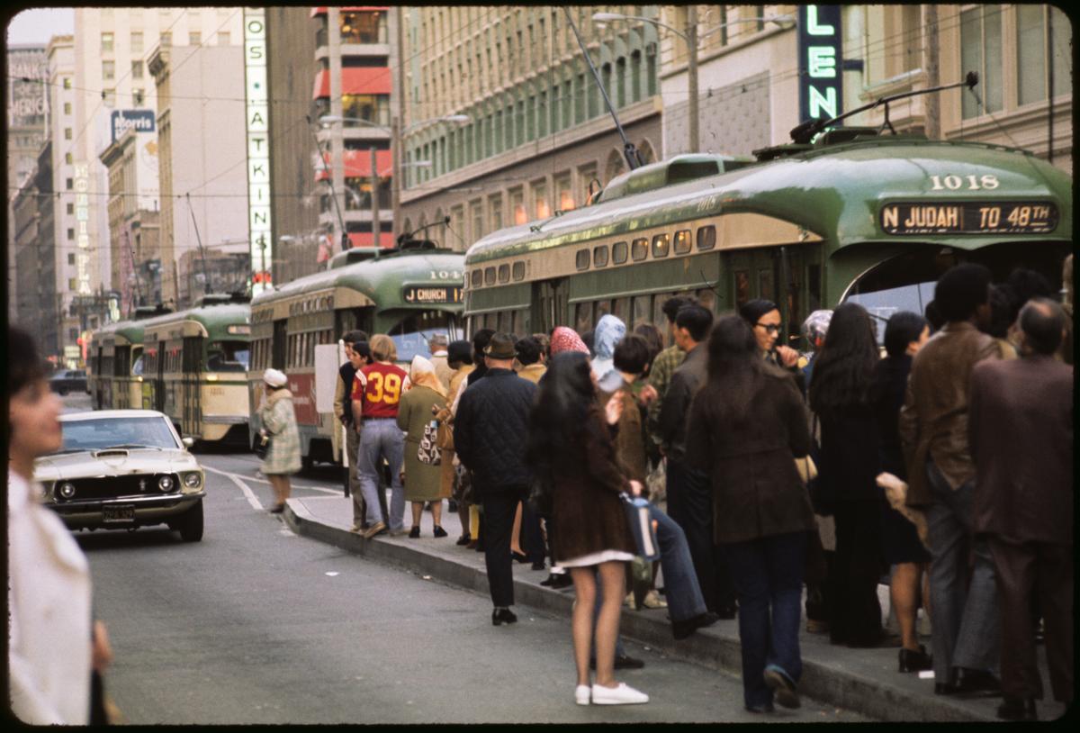
Muni platform overflowing with people as three streetcars approach and a car passes

This shot shows a typical evening rush hour scene from the mid-1970s taken at Market and Powell Streets. 

The color photos from this era are all part of a collection that was most likely used for presentations, studies and as general “stock” type photos of San Francisco, streets and Muni facilities and operations. Subjects include project documentation, copies of maps and charts, street scenes and “before and after” type photos showing Muni improvement projects being implemented. 

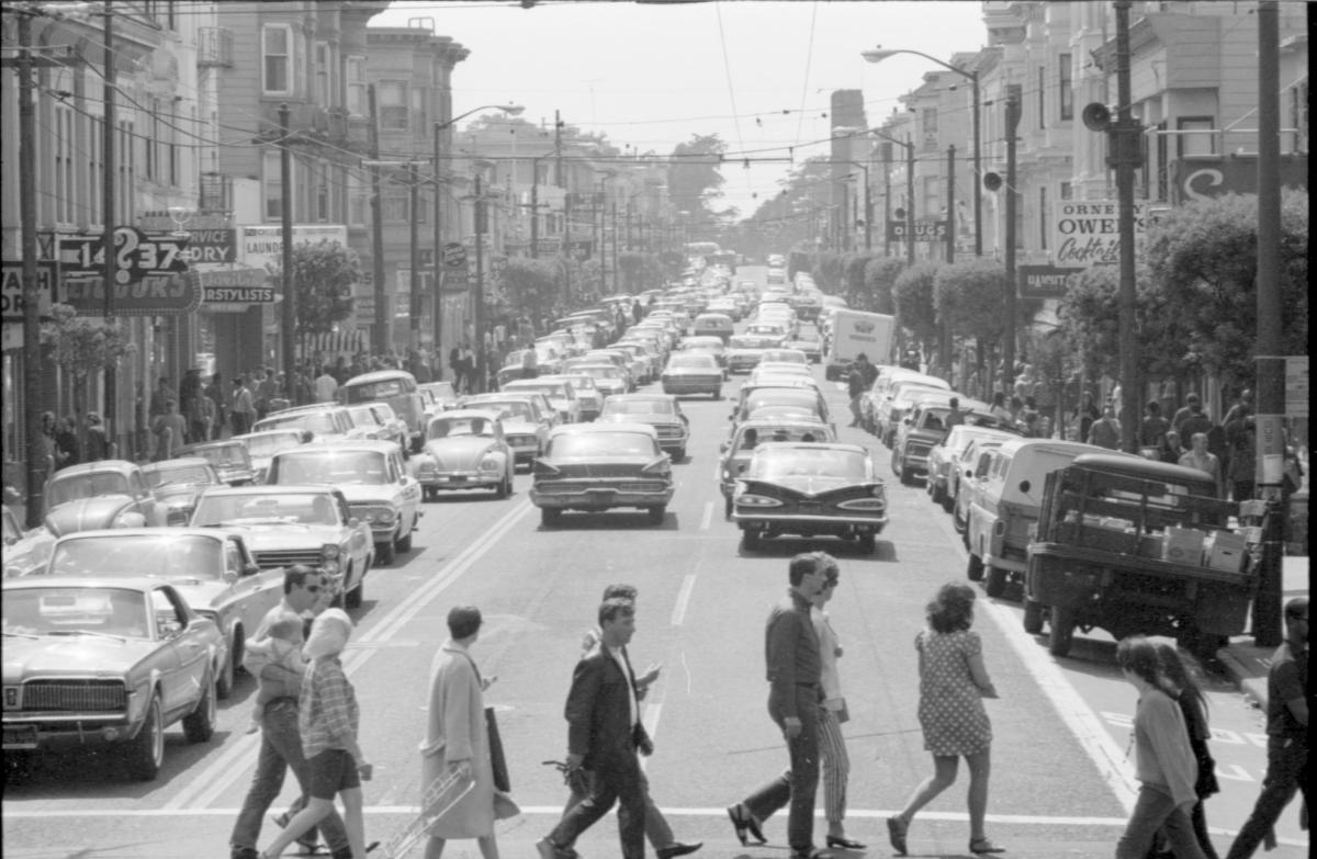
Photo of people crossing street in crosswalk. Street is full of classic cars.

This photo was taken on Haight Street during the 1967 “Summer of Love” to document the huge increase in traffic congestion along the corridor during that summer. 

The black and white photos from this new set of images were shot between 1962 and 1979 and cover a wide range of subjects from project documentation to typical street scenes, employee awards and public events. 

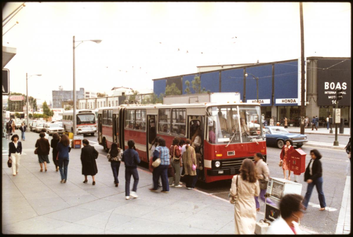
People boarding a Ikarus Articulating Bus on South Van Ness Avenue at Market Street

This articulated trolley bus was tested by Muni in the late 1970s-early 1980s, here it’s seen picking up passengers at Van Ness and Market.  Shots like this would have been used to show off the bus testing program at meetings. 

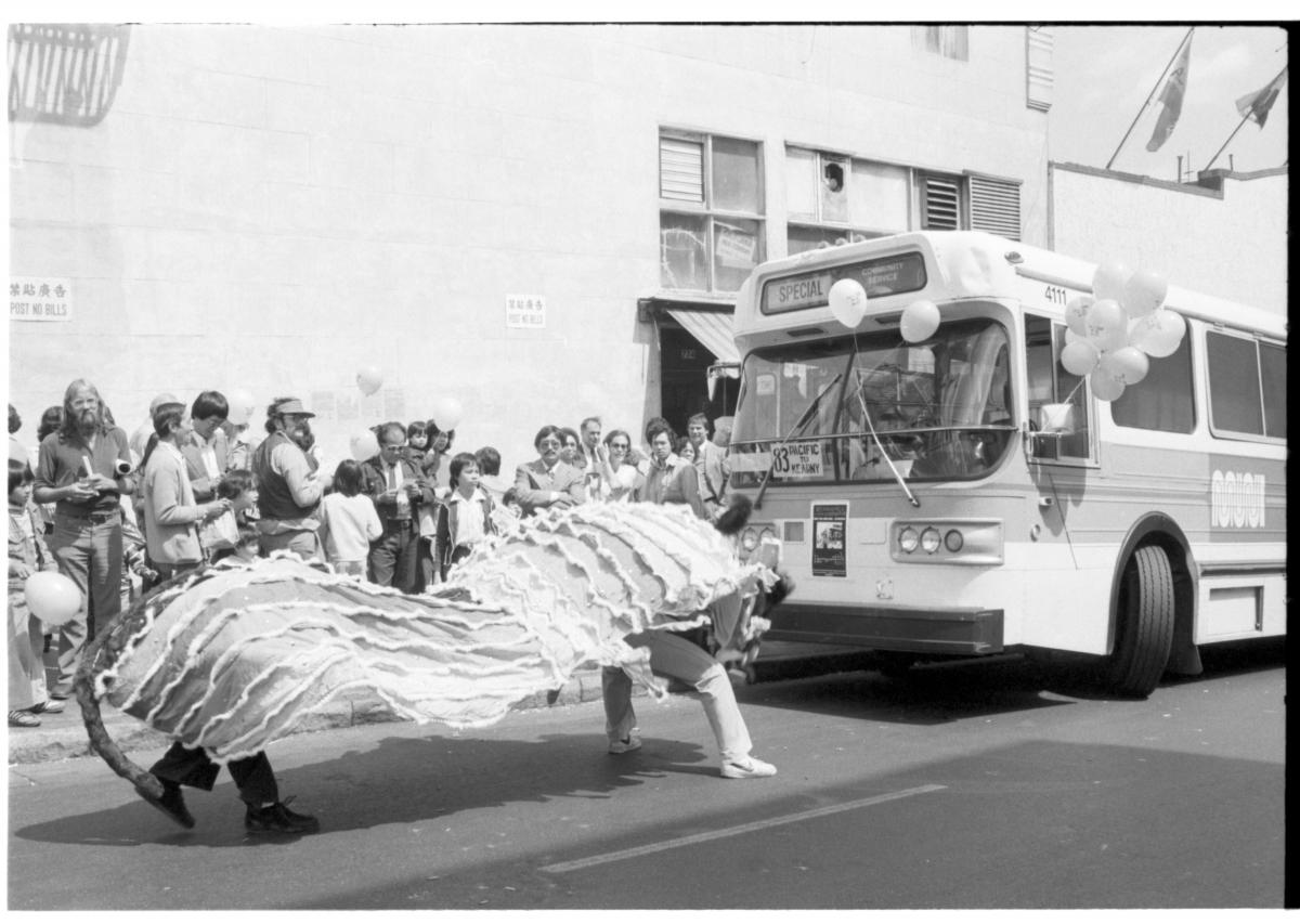
Lion dancers performing in front of a Muni bus

This shot from August 1979 was taken at an event to celebrate the launch of a new bus route, the 83-Pacific Avenue.  The 83 was part of Muni’s efforts to expand service to neighborhoods and create more transit connections outside of downtown.

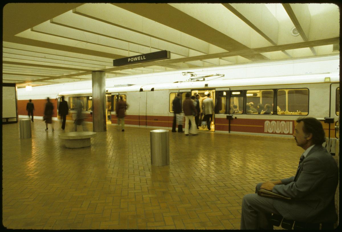
Man sitting in Powell Station as people board a Muni Metro

In the early 1980s, the Muni Metro subway system opened.  This shot inside Powell Station shows passengers boarding one of San Francisco’s first light rail vehicles, which were designed to operate above and below ground in the new system. 

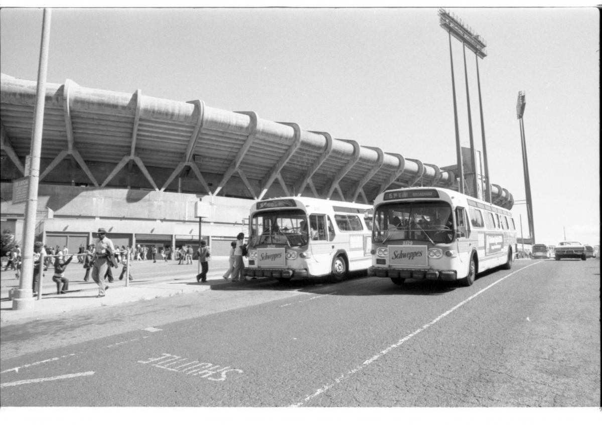
Muni buses outside Candlestick Park

Many long-time San Francisco sports fans will recognize this scene of Muni buses outside Candlestick Park in this late-1970s photo. Muni would operate special bus service to the park on game days to help get people to and from the arena. 

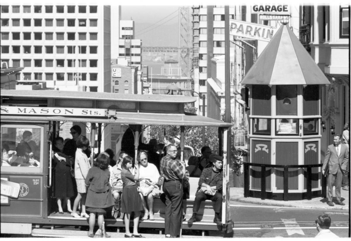
Cable car passes over top of Nob Hill

This classic cable car scene on Nob Hill shows a cable car crossing California Street on Powell with downtown and the Bay Bridge in the background. 

Altogether, there are over 1,700 photos now online that show Muni and San Francisco during an era of transition for the city and our transit system. Check them all out at SFMTA.com/photo


Published July 30, 2021 at 07:15AM
https://ift.tt/3idZduU

Tuesday, July 27, 2021

Destination San Francisco: Muni Gets You to All the Sights

Destination San Francisco: Muni Gets You to All the Sights
By

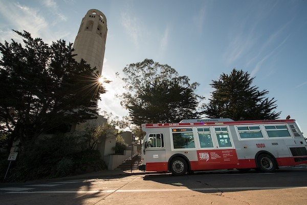
Photo depicting a Muni bus next to Coit Tower.

39 Coit servicing Coit Tower at Telegraph Hill – one of the routes that will be returning in August 2021 as part of Muni’s next service changes.

San Francisco is reopening and the SFMTA is supporting economic recovery by providing Muni access to 98% of the city. By August 2021, a majority of our pre-COVID routes will be back in service connecting residents and visitors with world-class shopping and dining experiences, off-the-beaten-path local flare, diverse neighborhoods and almost boundless outdoor activities. 

Shops, Markets & Dining in Diverse Neighborhoods 

Virtually every neighborhood in San Francisco has its own boutique shopping and dining experiences, as well as unique farmers markets showcasing local shops and amenities.  

With service to 24th Street in the city’s Latino Cultural District, the 67 Bernal Heights (restored August 2020) will take you to Alemany’s Saturday Farmers Market and Sunday Flea Market.  

Or groove on the 22 Fillmore (original Core Service route) through the Fillmore District – once known as the Harlem of the West – through the heart of the Mission for one of San Francisco’s world-famous burritos. Beginning August 14, 2021, late-night service will be extended to midnight on the 22 Fillmore and several other routes. 

Take the 1 California (original Core Service route) from Embarcadero Center to the Richmond District, where you’ll find boutiques, quaint cafes, cozy restaurants, bakeries and a vibrant weekend farmers market. Then ride the 38 Geary or 38R Geary Rapid (original Core Service routes) to Japantown for a crepe and take home a bonsai tree to cultivate your COVID-19 green thumb. 

The KT Ingleside-Third Street (restored May 2021) connects Ingleside to Mission Bay and several Hunter’s Point-Bayview markets, passing through the Dogpatch where customers can find classic beignets and new sports bars. With proximity to the ballpark, Chase Center and waterfront, experience food, culture and local artistry in San Francisco’s historic African American neighborhoods.  

Want to explore the culinary heart of Chinatown? Catch the 45 Union (restored August 2020) or 8 Bayshore (modified May 2021) to Chinatown’s fresh produce and seafood markets. 

You can get an authentic taste of Italy in North Beach – one of San Francisco’s oldest neighborhoods and historic home of the city’s Italian American and Greek communities. Catch the 30 Stockton (modified August 2020) to Joe DiMaggio Park, or all the way to the restored Crissy Field marshlands.  

Get Outdoors 

Choose one of eight routes – soon to be nine on August 14 – to Golden Gate Park. See the list below. 

Take the 24 Divisadero to Sanchez Street, or the 55 Dogpatch to Arkansas Street, and enjoy the city’s most popular Slow Streets for some fun in the fog (or sun). Ride the 5 Fulton (original COVID-19 Core Service route) to a picnic in historic Alamo Square. 

The 9 San Bruno or 9R San Bruno Rapid (restored June 2020) will take you to Portola –known for its plentiful community gardens. Transfer to the 29 Sunset (original Core Service route) to visit McLaren Park, or the 44 O’Shaughnessy (original Core Service route) to explore picturesque Forest Hill.  

For a swing on Billy Goat Hill, take the 24 Divisadero (original Core Service route) then ride to the Castro and catch the F Market & Wharves (restored May 2021) historic streetcar to the bocce courts at Justin Herman Plaza. 

If a day by the ocean is what you seek, the N Judah (restored May 2021) takes customers out to La Playa for a stroll on the Great Highway temporary promenade. Stop by the Sunset Farmers Market and Mercantile first or grab a bite along Judah Street. 

More Connections Coming in August  

In August, with the return of the 39 Coit and the 35 Eureka, you can almost touch the stars from one of San Francisco’s renowned hills and connect to neighborhoods like West Portal, the Outer Sunset, Bernal Heights and Merced Manor. Read our blog to learn more. 

Looking for help with homework as schools reopen? Every San Francisco public library is within steps of a Muni stop. Plan your tips to school with our Back-to-School resources and sign up for the Free Muni for Youth Program

We also plan to ring in the fall by reintroducing the historic Powell-Hyde Cable Car line in September. Enjoy the night lights of Union Square to the hot chocolate of Ghirardelli’s. 

Whether you’re coming from out of town, getting kids back to school or planning your “staycation,” let Muni be your guide on one of our many great routes! 

Muni routes to Golden Gate Park: 

  • N Judah - serves Tenderloin, Chinatown and SoMa 

  • 5 Fulton - serves Western Addition, Tenderloin, Chinatown and SoMa 

  • 7 Haight 

  • 18 46th Avenue - returning August 14 

  • 28 19th Avenue 

  • 29 Sunset - serving Oceanview/Ingleside, Excelsior/Outer Mission and Visitacion Valley 

  • 33 Ashbury - serving the Mission 

  • 43 Masonic - serving Oceanview/Ingleside 

  • 44 O'Shaughnessy -  serving Excelsior/Outer Mission and the Bayview 


Published July 28, 2021 at 01:34AM
https://ift.tt/3x94ub5

View24

View24