Friday, January 8, 2021

How Public Input is Helping Shape a Better Market Street

How Public Input is Helping Shape a Better Market Street
By Mariana Maguire

In response to budget constraints and challenges resulting from the COVID-19 pandemic, the Better Market Street project team released updated design proposals for Market Street between 5th and 8th streets in September 2020. We then hosted multiple stakeholder and public meetings, posted a public survey and held a month-long virtual open house in order get feedback on the proposals.

We received and reviewed hundreds of public comments and found four recurring areas of concern:

  • curb lane sharing,
  • speed tables,
  • curbs between vehicle lanes and
  • car-free Market Street enforcement.

Based on these issues, we are proposing the following additional modifications:

  • Lowering the speed limit to 20 miles per hour between Franklin and Steuart streets
  • Adding speed tables next to boarding islands to slow vehicle traffic and discourage speeding where transit riders and pedestrians are more vulnerable
  • Removing previously proposed mountable curbs between vehicle lanes and explore other ideas for lane separators and
  • Exploring the use of traffic cameras to monitor illegal turns onto Market Street and issue citations in order to improve enforcement of the Market Street ban on private vehicles

We also will make several changes to improve safety for people walking and biking, while maintaining access for taxis and commercial vehicles along the majority of Market Street. These include:

  • Installing signage clearly indicating that taxis and paratransit may use loading zones at all times (already completed) and
  • Implementing four new required right turns for taxis and commercial vehicles, eastbound at 8th and 6th streets and westbound at Kearny/Geary and Turk streets.

This will further reduce conflicts between motorized vehicles and people walking and biking along one of San Francisco’s highest injury corridors.

Illustration of Market Street showing various turn restrictions

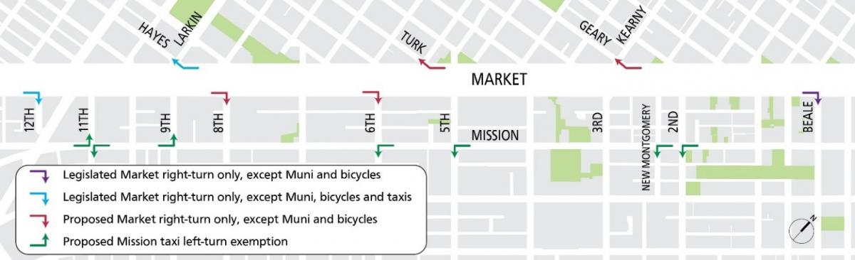
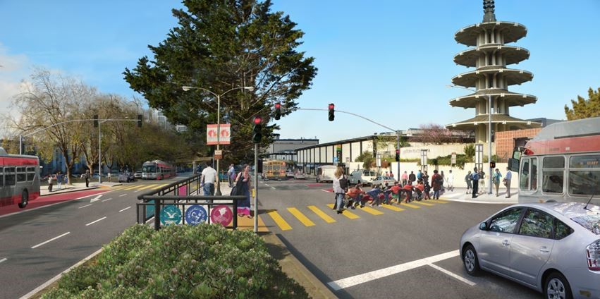
Illustration of existing and new proposed required right turns off Market Street and turn exemptions on Mission Street.

These changes build upon those approved in 2019 including: 

  • Implementing peak hour, peak direction commercial vehicle loading restrictions (6:00 - 9:30 a.m. south side, 3:00 - 7:30 p.m. north side) to reduce conflicts during rush hours
  • Requiring right turns for commercial vehicles at three locations (eastbound at 12th and Beale street, and westbound at Hayes and Larkin street).

Also, exempting taxis from left-turn restrictions along Mission Street (eastbound at 11th and 9th streets, westbound at 2nd, New Montgomery, 5th, 6th and 11th streets) will facilitate taxi mobility along the Mission Street Bus and Taxi only lanes, offsetting the added restrictions on Market Street.

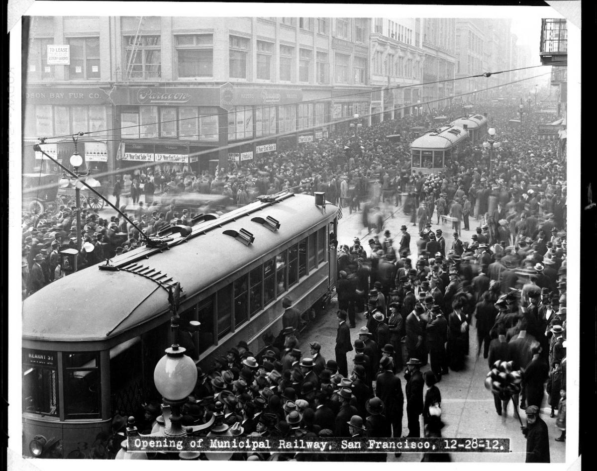
Market Street is one of our city’s busiest areas for people walking and biking. As a part of San Francisco’s high-injury corridor, it includes four of the top ten most dangerous intersections involving collisions for people on bikes and for pedestrians. The creation of a Car-free Market Street initiated the beginning of a safer era for everyone on Market Street. Lowering speeds for the remaining vehicles will further improve safety.

To accomplish this, we propose installing speed tables next to boarding islands. Speed tables help strengthen the 10-mile-per-hour safety zones next to boarding islands and will help reduce overall speeds on Market Street. To discourage speeding, vehicles will not be able to change lanes to avoid the speed tables at the new proposed locations.

Illustration of Market Street between 5th and 8th streets showing placement of speed tables next to boarding islands

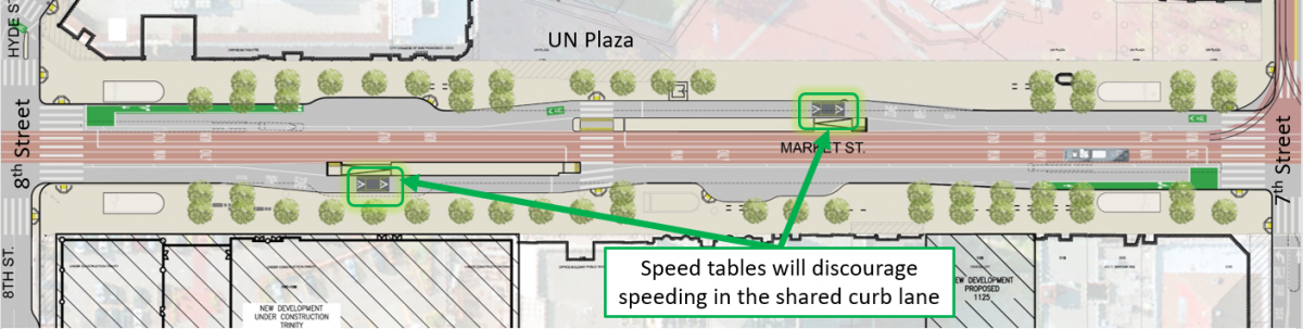
Illustration of new proposed speed table locations near boarding islands on Market Street.

Next Steps

On January 19, the SFMTA Board of Directors will consider minor additions to the 2019 legislation, including parking changes on Ellis, Hayes and Fell streets and turn restrictions to support the two-way conversion of Jones Street between Market Street and Golden Gate Avenue, as well as permanent adjustments near 2nd and Stevenson streets that were implemented on a temporary basis as part of car-free Market Street.

To see the public hearing notice for the SFMTA Board of Directors’ meeting on January 19, visit SFMTA.com/BetterMarketStreet. For project details visit the Better Market Street project website.


Published January 09, 2021 at 12:58AM
https://ift.tt/3nr9bbz

Thursday, January 7, 2021

Today in History: The Making of the Geary Expressway

Today in History: The Making of the Geary Expressway
By Sophia Scherr

Photo of crowd surrounding two Muni streetcars in downtown San Francisco in 1912

Crowds surround streetcars during their inaugural day of service, December 28, 1912 (SFMTA Photo Archives)

The SFMTA recently celebrated Muni’s 108th Anniversary on December 28, the date when streetcar service was inaugurated along Geary Street between downtown and 33rd Avenue on the A and B lines in 1912. This vital corridor is now experiencing its latest transformation. But first, some history:

Upon opening, for the cost of a nickel, the Geary streetcars went all the way to the Ocean Beach carousel, candy stands and other rides and amusements that would later be known as “Playland at the Beach.” Residences and shops began to spring up amid the sand dunes in the Outer Richmond, as transit connected downtown to the Richmond neighborhoods, Golden Gate Park and Ocean Beach.

The public transit network expanded in the years following this inaugural service through innovative projects like the completion of the Twin Peaks Tunnel and the establishment of the J Church and other lines. Ridership on Geary quickly became among the highest in San Francisco. Today Muni’s 38 Geary and 38R Geary Rapid continue to serve our highest volumes of customers, with more than 56,000 pre-pandemic daily riders expected to return once public health orders are lifted.

Photo of first motor bus meeting streetcar 101 in December 1917

 Muni's first motor bus (#01) meets streetcar 101 at the end of the A-Geary streetcar line on Fulton Street and 10th Avenue in December 1917. (SFMTA Photo Archives)

With the rise in car ownership, however, "auto fever" demands for automobile-centric developments ushered in the removal of rail infrastructure throughout the City beginning in the 1940s, implementing freeways and expressways in their place. The so-called “urban renewal” campaign of the 1960s and ‘70s also included construction of the eight-lane Geary Expressway, devastating communities by razing homes and storefronts, thereby displacing Black, Indigenous, and People of Color (BIPOC) residents, especially in the Fillmore and Japantown. The Geary Expressway continues to divide these communities as highway-like conditions make it difficult for people walking to cross the street.

Photo showing the construction of the Geary Expressway tunnel between Presidio and Masonic. 

View east from Presidio Avenue showing the construction of the Geary Expressway tunnel between Presidio and Masonic.

The Geary Rapid Project aims to bring these neighborhoods much-needed transit, pedestrian safety and civic improvements along a 3-mile stretch of the corridor, extending from Market to Stanyan streets, with construction expected to wrap up in summer 2021. This latest transformation comes long after priorities shifted from the mid-20th century focus that originally led to the construction of the Geary Expressway.

While we can never undo all the harm caused by this roadway, the Geary Rapid Project brings transit improvements and safety for people walking, developed in partnership with the communities most affected by the Geary Expressway construction. These improvements include travel time-reducing transit lanes, bus-bulb outs that reduce crossing distances for people walking and traffic signal upgrades. The project also includes a host of Vision Zero safety and accessibility benefits, to calm the expressway and make this high-injury corridor safer for people walking.  

Construction on Geary has continued smoothly throughout the COVID-19 pandemic and the project reached several, major milestones in 2020:

  • 1.5 miles of sewer and 1.8 miles of water upgrades were completed,
  • 30 new bulb-outs were installed and
  • crews removed the Steiner pedestrian bridge over Memorial Day weekend (see a time-lapse video here). The bridge will be replaced with improved surface crosswalks with larger pedestrian medians, including a new crosswalk on the east side of the intersection.

In addition to these improvements, “Muni head-start traffic signals” were recently turned on along Geary at 25th, 20th and 15th avenues as part of the 38 Geary Temporary Emergency Transit Lanes project. The signals give the 38 Geary and 38R Geary Rapid the go-ahead to start before other traffic, while also giving a head start to people walking across the street. The and new temporary transit lanes will be a welcome time-saver and help address crowding for people making essential trips as San Francisco begins reopening.

Artist's endering shows people crossing Geary using the median crossing being built at Geary and Buchanan streets.

A rendering shows people crossing Geary using the median crossing being built at Geary and Buchanan streets.

Final touches on Geary include a special community-centered crosswalk with decorative panels at Buchanan Street. The crosswalk symbolizes the re-connection of the two communities (Japantown and the Fillmore) that were separated by the Geary Expressway. The crosswalk design and development resulted from a close collaboration between the SFMTA and the local communities as a part of our commitment to better serve the city’s residents.

As the Geary Rapid Project wraps up construction later this year on time and on budget, we look forward to cutting the ribbon on a better Geary that both Muni customers and people walking can enjoy once San Francisco opens again.


Published January 08, 2021 at 02:39AM
https://ift.tt/3s3g3PU

Wednesday, January 6, 2021

Why Does Construction Take So Long?

Why Does Construction Take So Long?
By Amy Fowler

Tired of construction in San Francisco? You are not alone. With so many city projects and private developments raising dust across the city, our iconic skyline can more closely resemble a giant Erector set than a world-class city. Without these necessary upgrades, however, roads would crumble, traffic signals would be stymied by aging technology and century-old sewer and water pipes would be vulnerable to earthquakes and climate change.

 Photo of pedestrian refuge island under construction at Geary Boulevard and Steiner Street as part of the Geary Rapid Project.

New pedestrian refuge island under construction at Geary Boulevard and Steiner Street as part of the Geary Rapid Project.

But why does construction take so darn long?

There are many factors that can turn a seemingly simple project into an extraordinarily complex undertaking. Chief among them is that many SFMTA projects are done in the public right of way. Unlike private developments that are usually self-contained, our projects happen in areas where people need to walk, drive, bike and take transit.

Considerations like traffic control, maneuvering around existing utilities, providing adequate space for construction crews to work and maintaining access to neighboring businesses and homes all take a considerable amount of coordination. There may also be impacts to transit that require relocating a bus stop or safely rerouting people walking around construction sites. Support from utilities is often required when working around existing electrical wires, or additional SFMTA staff may be needed to isolate the overhead contact system that powers our zero-emissions electric-trolley buses.

There are also trade-offs to work out, like storing construction materials in a location that’s close enough for crews to work efficiently without causing too great a disruption to the neighborhood. And on busy thoroughfares like Van Ness Avenue or Geary Boulevard, all the work must happen within limited hours of the day to maintain traffic flow.

Every element of a project must be sequenced properly so that all the parts can move in sync. It’s like tipping over a stack of dominoes: if one of those dominoes gets moved due to a conflict, schedules or crews may need to be reshuffled to keep the overall work from being delayed.

So what about those trenches that are dug up, filled and then re-dug?

Underground utility work like replacing aging water or sewer mains is time-consuming and often requires trenches to be opened, covered and opened again. First, smaller holes are dug—a process called “potholing”—to determine the location of any existing utilities that may not appear accurately on utility records, including electric or gas lines. Then the work trench is carefully excavated, and any old or abandoned utilities that are in conflict are removed before the new pipes can be installed. In some cases, the project must be redesigned if unforeseen obstacles cannot simply be removed.

Water pipes must be disinfected and tested before reconnecting a property’s water service to a newly installed main; on some blocks there may be dozens of individual switchovers. Trenches must be covered the at the end of each shift for safety reasons and to restore travel lanes to vehicle traffic. Only when these steps are complete can crews restore the work area with a strong concrete base above the trenches and repave the roadway.

Another reason projects can be lengthy lies in the city’s excavation code, which aims to coordinate agencies’ work. The SFMTA works in close collaboration with our city partners in the Planning Department, Public Utilities Commission and Public Works to combine utility, transit, safety and streetscaping improvements into one package—which can sometimes make a project longer but means we don’t have to come back and tear up the road again every few years. Coordinating transit improvement projects with other planned work can therefor reduce overall disruption to communities and save money by reducing the amount of excavation needed.

Projects like Central Subway and the Van Ness, Geary Rapid and L Taraval Improvement are no exception when it comes to complexity. Each project has its own unique challenges based on existing conditions, scope of work and community considerations that can affect how work is sequenced.  

The SFMTA works closely with contractors, local businesses and residents to minimize construction impacts to the community. We know how difficult construction can be when it’s right at your doorstep, and we’re grateful for your patience as we work to build a better San Francisco.  

Muni Bus with sign advertising Japantown Open for Business

A Muni bus sign encourages visitors to Japantown, part of the Geary Rapid Project’s business support program. SFMTA projects include construction mitigation plans tailored to suit the local neighborhood and offset potential impacts.


Published January 07, 2021 at 01:44AM
https://ift.tt/3rXQ501

Tuesday, January 5, 2021

22 Fillmore Moves to Mission Bay, Makes Way for the 55 Dogpatch

22 Fillmore Moves to Mission Bay, Makes Way for the 55 Dogpatch
By Erin McMillan

22 Fillmore bus boarding passengers at bus stop.

Starting Saturday, January 23, the eastern section of the 22 Fillmore will shift its route to begin serving Mission Bay. Utilizing the new transit and street amenities along 16th Street, the 22 Fillmore will travel east from the Mission to 3rd Street to serve medical facilities and the growing residential and commercial areas in the Mission Bay neighborhood. In addition to increasing service to the Mission Bay neighborhood, this move will provide an improved east-west connector from the Mission neighborhood to Mission Bay, increasing transit access to jobs and healthcare services. This 5+ mile bus route serves nearly 18,000 daily customers from the Marina through the Mission and soon to Mission Bay, improving Muni service to all the neighborhoods in between.

Start of the 55 Dogpatch

Moving the eastern segment of the 22 Fillmore to Mission Bay provided an opportunity to work with the communities of Potrero Hill and the Dogpatch to find ways to improve transportation in their neighborhoods. Beginning with an initial assessment of transportation options and potential future development in the area, SFMTA worked to find what type of transit service would best serve these neighborhoods. After a few years of research and extensive outreach, the community-informed 55 Dogpatch was born as a new Muni route to maintain and enhance transit connections between 16th St Mission BART, Potrero Hill and the Dogpatch. Service on the 55 Dogpatch will also begin on Saturday, January 23.

These adjustments to Muni service comes after the completion of the first phase of the multi-agency 16th Street Improvement Project from Potrero Avenue to 3rd Street that includes new signalized intersections, new transit islands and transit bulbs for safer and more efficient bus boarding, new pedestrian bulbs to reduce crossing distances for people walking, new ADA ramps at each intersection, new street lights to illuminate the streets, 50 new trees along 16th street, curb-to curb paving and new sewer and water pipes. The completion of this phase means a safer and overall more pleasant experience for the community, Muni customers and people walking. This project made community-informed improvements to address the needs of current and future residents and is part of Muni Forward, an initiative to create a safe, reliable and comfortable experience on and off transit.

Additional information about all service changes that are planned to begin on Saturday, January 23 can be found on our blog.


Published January 06, 2021 at 03:31AM
https://ift.tt/3pRKXbV

View24

View24