By Benjamin Barnett
We are very excited to be moving forward with the third phase Slow Streets, which will connect new and existing Slow Streets together into a network that allows most San Franciscans to be able to access essential services and employment without being reliant on either a car or Muni.
With Muni’s reduced capacity due to COVID-19 physical distancing, an additional 30 percent of service on hold due to financial challenges, and congestion already reaching peak pre-COVID levels, Slow Streets and our bicycling network are key to supporting people getting where they need to go.
“In order to support further reopening of the economy, we need to make San Francisco more welcoming and accessible for people who want to travel on foot, bicycle, wheelchair, scooter, skateboard or other forms of micromobility,” said Jeffrey Tumlin, SFMTA Director of Transportation. “Slow Streets are critical infrastructure that attracts users of the full array of neighborhood demographics—including children, older adults, people with disabilities and people of color.”
Slow Streets have been wildly successful, and survey data indicates an 80 percent approval rating. The next phase of our Slow Streets program is now being reviewed and approved so we can expand the popular program more broadly across our city and make it accessible to all.
Traveling by car may feel more enticing in the COVID-19 era but driving takes up ten times as much space per person compared to travel by walking, biking and other modes. In addition, approximately one in ten car trips in San Francisco are under a mile and 46 percent are less than three miles – trips that for many are prime to be done in other ways given comfortable space. Taking short trips to neighborhood business corridors on foot or by bike is also a great way to support our local economy during these difficult economic times for small business.
Pending approval, the proposed Phase Three Slow Streets would install temporary barricades and signage at designated intersections along the following additional corridors:
- 20th Street from San Bruno to Pennsylvania avenues
- Arkansas from 23rd to 17th streets
- Arlington from Roanoke to Randall streets
- Cabrillo Street from 45th to 23rd avenues
- Cayuga Avenue from Naglee Avenue to Rousseau Street
- Clay Street from Arguello Boulevard to Steiner Street
- Duncan Street from Diamond Heights Boulevard to Tiffany Avenue
- Holly Park Circle
- Mariposa from Texas to Mississippi streets
- Minnesota from Mariposa to 22nd streets
- Noe Street from 23rd to Duboce streets
- Pacific Avenue from Steiner to Gough streets
- Pierce from Hayes to Duboce streets
- Tompkins Avenue from Andover Street to Peralta Avenue
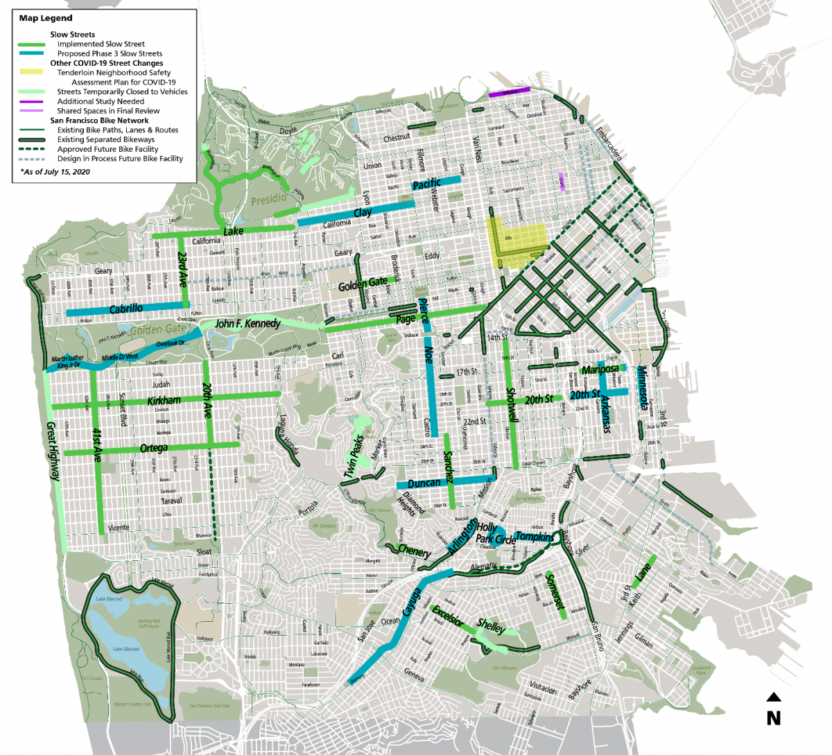
Map of currently implemented and proposed Phase 3 Slow Streets along with a Shared Spaces street closure. Also included is our bike network highlighting separated bikeways, approved projects and those in the design pipeline.
We’re also interested in making sure all San Franciscans--particularly children from low income families--have access to open space. That’s why we’re extending the 30 Stockton to Crissy Field and creating a continuous, family-friendly path from the Panhandle to the Zoo. We are grateful for the support of Rec & Park for helping us allocate space in Golden Gate Park so that more San Franciscans can safely access open space, especially given the unique COVID-19 transmission science.
“Having room to safely exercise outdoors is critical for our mental and physical health,” said San Francisco Recreation and Park Department General Manager Phil Ginsburg, "Golden Gate Park is an oasis for socially distant recreation and I am thrilled this phase of Slow Streets extend a car-free path of travel all the way to the ocean.”
Shared Spaces
Our map also highlights two full street closures in final review as a part of the Shared Spaces program. This program allows businesses, merchant groups and community organizations to apply to open streets to support business activities as part of COVID-19 economic recovery. This includes full street closures or changes like repurposing parking in front of a business. Some possible uses include outdoor seating for cafes and restaurants, retail displays, or sales and service offerings.
Starting this Saturday, July 18, Grant Avenue between California and Washington streets in Chinatown is to be open for community activity on weekends from 9:00 a.m. to 8:00 p.m. There are more Shared Spaces applications being analyzed throughout the city and we will continue to support local business activities through this innovative program.
What’s Next?
We’ve been tailoring our approaches to the needs of each neighborhood and supervisorial district. In District 3, for example, we’ve been focused on Shared Spaces to help merchants and restoration of Muni service to neighborhoods with the highest transit demand in the city. In Bayview, Hunters Point, and Visitacion Valley in District 10, we’ve been focused not only on restoring pre-COVID Muni service, but also in-service transit improvements to neighborhoods most lacking in local services, and in the greatest need of access to employment and other opportunities.
Slow Streets Project Background
Within weeks of the mayor’s declaration of shelter-in-place directive, the SFMTA began planning for and implementing temporary emergency Slow Streets to provide additional space for physical distancing during essential active transportation trips. These Slow Streets were approved through the city’s emergency operation command system, including review from other agencies across the city, and with an emergency statutory exemption under CEQA. They were implemented with temporary barricades and signage at designated intersections to identify the street as a shared space for vehicles, bicycles and pedestrians.
The Slow Streets Program is intended to allow roadways to be used as a shared space for foot and bicycle traffic with adequate space for travelers to maintain six-foot separation. This space is needed for essential walk and bike travel while transit service levels are temporarily reduced. Vehicle traffic is allowed on these streets but is limited to local traffic (e.g. access for residents and visitors of residents), mail, delivery services and emergency vehicle access. Collectively, the bicycle network, Slow Streets, Shared Spaces, and our existing sidewalk system provides more options for many.
Slow Streets don’t work everywhere. Successful Slow Streets generally have these qualities:
- Approximately 6-8 blocks long
- No more than two lanes, preferably one in each direction
- Residential areas
- Mostly flat
- Connections to bike lanes and parks
- Stop sign-controlled intersections, 4-way stops are best
- No Muni, commercial loading or emergency route conflicts
Slow Streets does not legally change the designation of the public right-of-way; people walking or running in the street are allowed to be in the street as the California Vehicle Code currently permits, but people walking or running are required to yield to vehicular traffic.
Slow Streets are for essential trips, not neighborhood gathering points. We also encourage everyone to follow current health guidelines, bring a face covering and maintain proper physical distance from people outside their households.
For updates, additional information and to provide input on the SFMTA’s Slow Street Program, visit the program webpage at SFMTA.com/SlowStreets. Please also visit SFMTA.com/COVID19 for the latest agency updates about our COVID-19 response.
Published July 17, 2020 at 01:00AM
https://ift.tt/2OsAFP0


